Tuesday, October 30, 2007


The geology of Minnesota is the study of the rock, minerals, and soils of the U.S. state of Minnesota, including their formation, development, distribution, and condition.
The state's geologic history can be divided into three periods. The first period was a lengthy period of geologic instability from the origin of the planet until roughly 1,100 million years ago. During this time, the state's Precambrian bedrock was formed by volcanism and the deposition of sedimentary rock and then modified by processes such as faulting, folding and erosion. In the second period, many layers of sedimentary rock were formed by deposition and lithification of successive layers of sediment from runoff and repeated incursions of the sea. In the third and most recent period, glaciation eroded previous rock formations and deposited deep layers of glacial till over most of the state, and created the beds and valleys of modern lakes and rivers.
Minnesota's geologic resources have been the historical foundation of the state's economy; enormous industries have been built around its extractive geological resources. Precambrian bedrock has been mined for metallic minerals, including iron ore, on which the economy of Northeast Minnesota was built. Archaen granites and gneisses, and later limestones and sandstones, are quarried for structural stone and monuments. Glacial deposits are mined for aggregates, glacial till and lacustrine deposits formed the parent soil for the state's farmlands, and glacial lakes are the backbone of Minnesota's tourist industry. These economic assets have in turn dictated the state's history and settlement patterns, and the trade and supply routes along the waterways, valleys and plains have become the state's transportation corridors.

Geological history
Minnesota contains some of the oldest rocks on Earth, granitic gneisses that formed some 3,600 mya (million years ago) — roughly 80% the age of the planet. The rifting stopped before the land could become two separate continents. About 100 million years later, the last volcano went quiet.

Formation of Precambrian bedrock
The mountain-building and rifting events left areas of high relief above the low basin of the Midcontinent rift. Over the next 1,100 million years, the uplands were worn down and the rift filled with sediments, forming rock ranging in thickness from several hundred meters near Lake Superior to thousands of meters further south. Other land animals followed as the dinosaurs disappeared, but much of the physical evidence from this era has been scraped away or buried by recent glaciation.

The Ice Ages
Contemporary Minnesota is much quieter geologically than in the past. Lava flows are the only remaining traces of the volcanism that ended over 1,100 mya. The state is now roughly 400 miles (600 km) from the seas that once covered it, and the continental glaciers have receded entirely from North America. The state's landscape is a relatively flat peneplain; its highest and lowest points are separated by only 1699 feet of elevation.
While the state no longer has true mountain ranges or oceans, there is a fair amount of regional diversity in landforms and geological history, which in turn has affected Minnesota's settlement patterns, human history, and economic development. These diverse geological regions can be classified several ways. The classification used below principally derives from Sansome's Minnesota Underfoot - A Field Guide to Minnesota's Geology, but is also influenced by Minnesota's Geology by Ojakangas and Matsch. These authorities generally agree on areal borders, but the regions as defined by Ojakangas and Matsch are more geographical in their approximations of areas of similar geology, while Sansome's divisions are more irregular in shape in order to include within a region all areas of similar geology and give particular emphasis to the effects of recent glaciation.

Minnesota today
Northeast Minnesota is an irregularly-shaped region composed of the northeasternmost part of the state north of Lake Superior, the area around Jay Cooke State Park and the Nemadji River basin southwest of Duluth, and much of the area east of U.S. Highway 53 that runs between Duluth and International Falls. Excluded are parts of the beds of glacial lakes Agassiz and Upham, the latter now occupied by the upper valley of the St. Louis River and its tributary the Cloquet.
Known as the Arrowhead for its shape, this region shows the most visible evidence of the state's violent past. There are surface exposures of rocks first formed in volcanic activity some 2,700 mya during construction of the Archaen-Superior province, While high-grade ores have now been exhausted, lower-grade taconite continues to supply a large proportion of the nation's needs.

Geology of Minnesota Northeast Minnesota: ancient bedrock
Northwest Minnesota is a vast plain in the bed of Glacial Lake Agassiz. This plain extends north and northwest from the Big Stone Moraine, beyond Minnesota's borders into Canada and North Dakota. In the northeast, the Glacial Lake Agassiz plain transitions into the forests of the Arrowhead. The region includes the lowland portions of the Red River watershed and the western half of the Rainy River watershed within the state, at approximately the level of Lake Agassiz' Herman Beach. At marginally higher elevations within these wetlands are areas of black spruce, tamarack, and other water-tolerant species.

Northwest Minnesota: glacial lakebed
Southwest Minnesota is in the watersheds of the Minnesota River, the Missouri River, and the Des Moines River. Due to the quaternary and bedrock geology of the region, as well as the reduced precipitation in the region, groundwater resources are neither plentiful, nor widely distributed, unlike most other areas of the state. Given these constraints, this rural area hosts a vast network of water pipelines which transports groundwater from the few localized areas with productive groundwater wells to much of the region's population.

Southwest Minnesota: glacial river and glacial till
Southeast Minnesota, wholly included in the Driftless Area, is separated from Southwest Minnesota by the Owatonna Moraine, the eastern branch of the Bemis Moraine, a terminal moraine of the Des Moines lobe from the last Wisconsin glaciation.
The bedrock here is lower Paleozoic sedimentary rocks, with limestone and dolomite especially prevalent near the surface. To the east, the area is highly dissected, where local tributaries of the Mississippi have cut deep valleys into the bedrock. It is an area of karst topography, with thin topsoils lying atop porous limestones, leading to formation of caverns and sinkholes. The last glaciation did not cover this region (halting at the Des Moines terminal lobe mentioned above), so there is no glacial drift to form subsoils, giving the region the name of the Driftless area. As the topsoils are shallower and poorer than those to the west, dairy farming rather than cash crops is the principal agricultural activity.

Southeast Minnesota: bluffs, caves and sinkholes
Central Minnesota is composed of (1) the drainage basin of the St. Croix River (2) the basin of the Mississippi River above its confluence with the Minnesota, (3) those parts of the Minnesota and Red River basins on the glacial uplands forming the divides of those two basins with that of the Mississippi, (4) the Owatonna Moraine atop a strip of land running from western Hennepin County south to the Iowa border, and (5) the upper valley of the St. Louis River and the valley of its principal tributary the Cloquet River which once drained to the Mississippi before they were captured by stream piracy and their waters were redirected through the lower St. Louis to Lake Superior.
At the surface, the entire region is "Moraine terrain", with the glacial landforms of moraines, drumlins, eskers, kames, outwash plains and till plains, all relics from recent glaciation. In the multitude of glacier-formed depressions are wetlands and many of the state's "10,000 lakes", which make the area prime vacation territory. The glacial deposits are a source of aggregate, and underneath the glacial till are high-quality granites which are quarried for buildings and monuments.

Central Minnesota: knob and kettle country
The subregion of East Central Minnesota is that part of Central Minnesota near the junction of three of the state's great rivers. Included are Dakota County, eastern Hennepin County, and the region north of the Mississippi but south of an east-west line from Saint Cloud to the St. Croix River on the Wisconsin border. It includes much of the Twin Cities metropolitan area.

East Central Minnesota: bedrock valleys and outwash plain

Sources

Chandler, Val W (2005-08-03). A Geophysical Investigation of the Ely Greenstone Belt in the Soudan Area, 4-5. Open File Report 05-1. Minnesota Geological Survey. Retrieved on 2007-06-30.
Heinselman, Miron (1996). The Boundary Waters Canoe Area Wilderness Ecosystem. Minneapolis: University of Minnesota Press. ISBN 0-8166-2804-1. 
Heinselman, Miron L. (Autumn 1963). "Forest Sites, Bog Processes, and Peatland Types in the Glacial Lake Agassiz Region, Minnesota". Ecological Monographs 33 (4): 327-374. Ecological Society of America. DOI:10.2307/1950750. Retrieved on 2007-06-30. 
Lusardi, B.A. (1997). Quaternary Glacial Geology. Minnesota at a Glance. Minnesota Geological Survey, University of Minnesota. Retrieved on 2007-06-30.
Morey, G. B. (February 1999). "(Abstract) High-grade iron ore deposits of the Mesabi Range, Minnesota; product of a continental-scale Proterozoic ground-water flow system". Economic Geology and the Bulletin of the Society of Economic Geologists 94 (1): 133-42. Society of Economic Geologists. Retrieved on 2007-06-30. 
Nute, Grace Lee (1950). Rainy River Country. Saint Paul: Minnesota Historical Society, 3. 
Ojakangas, Richard W. & Charles L Matsch (1982), Minnesota's Geology, Minneapolis: University of Minnesota Press, ISBN 0-8166-0953-5
Sansome, Constance Jefferson (1983), Minnesota Underfoot: A Field Guide to Minnesota's Geology, Stillwater, MN: Voyageur Press, ISBN 0-8965-8036-9
Van Schmus, W. R.; Hinze, W. J. (May 1985). "The Midcontinent Rift System". Annual Review of Earth and Planetary Sciences 13: 348. Annual Reviews. DOI:10.1146/annurev.ea.13.050185.002021. Retrieved on 2007-06-30. 
Upham, Warren (1896/2002). "The Glacial Lake Agassiz". Monographs of the United States Geological Survey XXV. United States Geological Survey/University of North Dakota. Retrieved on 2007-06-30. 
Waters, Thomas F. (1977), The Streams and Rivers of Minnesota, Minneapolis: University of Minnesota Press, ISBN 0-8166-0821-0

Monday, October 29, 2007

Mars 1
The Mars 2 and Mars 3 missions consisted of identical spacecraft, each with an orbiter and an attached lander; they were the first human artifacts to touch down on Mars. The orbiters' primary scientific objectives were to image the Martian surface and clouds, determine the temperature on Mars, study the topography, composition and physical properties of the surface, measure properties of the atmosphere, monitor the solar wind and the interplanetary and Martian magnetic fields, and act as communications relays to send signals from the landers to Earth. Mars 2 and 3 were launched by Tyazheliy Sputniks.

Mars 2 and 3

Main article: Mars 2 Mars 2

Main article: Mars 3Mars 4 Mars 3
Mars 4, 5, 6, and 7 comprised an associated group of Soviet spacecraft launched towards Mars in July and August of 1973. The Mars 4 and 5 automatic stations were designed to orbit Mars and return information on the composition, structure, and properties of the Martian atmosphere and surface. The spacecraft were also designed to act as communications links to the Mars 6 and 7 landers. They were launched from Earth by Proton SL-12/D-1-e boosters.
The 1973 Mars launch window was inefficient and thus the Proton rocket could not deliver the mass to Mars, as had been possible in 1971. Thus, the mission was split somewhat extravagantly into four separate, but lighter vehicles: two relay orbiters without landers and two orbiter type buses with landers but without fuel to enter orbit. The political purpose of these missions was to beat the American Viking probes (scheduled for 1975 launches) to be the first spacecraft to soft land on Mars, at which they did not succeed.

Mars 4, 5, 6 and 7
The Mars 4 orbiter reached Mars on 10 February 1974. Due to a flaw in the computer chip which resulted in degradation of the chip during the voyage to Mars, the retro-rockets designed to slow the craft into Mars orbit did not fire , and Mars 4 flew by the planet at a range of 2200 km. It returned one swath of pictures and some radio occultation data which constituted the first detection of the nightside ionosphere on Mars. It continued to return interplanetary data from solar orbit after the flyby.

Launch Date/Time:

  • Mars 4: July 21, 1973 at 19:30:59 UTC
    On-orbit mass:

    • Dry: 2270 kg
      Fully-fuelled: 3440 kg Mars 4
      Mars 5 reached Mars on February 12, 1974 at 15:45 UT and was inserted into an elliptical 1755 by 32,555 km, 24 h 53 min orbit with an inclination of 35.3 degrees. Nearly synchronized with the rotation of the planet, its two phototelevision cameras could be commanded to take 12 pictures during each close approach. The "Vega" camera used a wide area 52mm lens with color filters, the "Zulfar" camera used a telescopic 350mm lens and long-pass orange filter. Images were transmitted in a rapid 220-line mode, and then selected pictures were retransmitted at 880 or 1760 line resolution. Mars 5 collected data for 22 orbits until a loss of pressurization in the transmitter housing ended the mission. About 60 images were returned over a nine day period showing swaths of the area south of Valles Marineris, from 5° N, 330° W to 20° S, 130° w.

      Launch Date/Time:

      • Mars 5: July 25, 1973 at 18:55:48 UTC
        On-orbit mass:

        • Dry: 2270 kg
          Fully-fuelled: 3440 kg Mars 5
          Mars 6 successfully lifted off into an intermediate Earth orbit on a Proton SL-12/D-1-e booster and then launched into a Mars transfer trajectory. Total fueled launch mass of the lander and bus was 3260 kg. It reached Mars on March 12, 1974. The descent module separated from the bus at a distance of 48,000 km from Mars. The bus continued on into a heliocentric orbit after passing within 1600 km of Mars. The descent module entered the atmosphere at 09:05:53 UT at a speed of 5.6 km/s. The parachute opened at 09:08:32 UT after the module had slowed its speed to 600 m/s by aerobraking. During this time the craft was collecting data and transmitting it directly to the bus for immediate relay to Earth. Contact with the descent module was lost at 09:11:05 UT in "direct proximity to the surface", probably either when the retrorockets fired or when it hit the surface at an estimated 61 m/s. Mars 6 landed at 23.90° S, 19.42° W in the Margaritifer Terra region of Mars. The landed mass was 635 kg. The descent module transmitted 224 seconds of data before transmissions ceased, the first data returned from the atmosphere of Mars. Unfortunately, much of the data were unreadable due to a flaw in a computer chip which led to degradation of the system during its journey to Mars.

          Mars 6
          Mars 7 successfully lifted off into an intermediate Earth orbit on a Proton SL-12/D-1-e booster and then launched into a Mars transfer trajectory. Total fueled launch mass of the lander and bus was 3260 kg. It reached Mars on March 9, 1974. Due to a problem in the operation of one of the onboard systems (attitude control or retro-rockets) the landing probe separated prematurely (4 hours before encounter) and missed the planet by 1300 km. The early separation was probably due to a computer chip error which resulted from degradation of the systems during the trip to Mars. The intended landing site was 50° S, 28° W. The lander and bus continued on into heliocentric orbits.

          Mars 7

          Later missions

          Main article: Phobos program Mars 96

Sunday, October 28, 2007

Shakhtar Stadium (future)
Shakhtar Stadium is a football-only stadium in Donetsk, Ukraine, currently under construction. The stadium will hold 50,000 people and will be completed in 2008. It will be used as one of the Euro 2012 venues. The stadium's specifications can meet 5-star UEFA rating, which would make it the first 5-star UEFA stadium in Ukraine. It will also be the 2nd largest stadium in Ukraine after the Kiev's Olimpiysky stadium.

Saturday, October 27, 2007

Manchester Wolves
The Manchester Wolves are a professional arena football team, based at the Verizon Wireless Arena in Manchester, New Hampshire. They play in the East Division of the American Conference of the af2 league, which is the minor league of the Arena Football League. Coach Ben Bennett returns for his third season of coaching the Wolves in 2007. In 2006, Bennett led the team to a 9-7 regular season record and a first round victory in the post-season.

Season-by-season

Steve Bellisari - QB/S
William Haith - DS
Dylan Pohlman - K

Friday, October 26, 2007


The Turtle ship (also known as Geobukseon or Kobukson by its Korean name) was a type of large warship belonging to the Panokseon class in Korea that was used by the Royal Korean Navy during the Joseon Dynasty from the early 15th century up until the 19th century.
Turtle ships are famous for participation in numerous victories during the Japanese invasions of Korea (1592-1598), where they inflicted costly damage upon Hideyoshi's efforts to conquer Korea.
The first references to older, first generation turtle ships come from 1413 and 1415 records in the Annals of the Joseon Dynasty. These turtle ships were mentioned as "spear-ships" or "ramming ships" and were mainly used against Japanese pirates that caused minor disturbances in Korean coastal areas. These early turtle ships soon fell out of use, though, because of a long period of relative peace and almost no maritime military operations.
The Korean admiral Yi Sun-sin is credited with designing and building the craft known today. His turtle ships were equipped with at least five different types of cannons during the Japanese invasions of Korea (1592-1598). Yi Sun-sin's turtle ships had deck shielding, in the form of thin iron plates or spikes. He had three to five turtle ships built, while in 1782, there were at least 40 commissioned of them.

Construction
Several different versions of the turtle ships served during the war, but in general they were about 100 to 120 feet long (30 to 37 meters long), and strongly resembled the Panokseon's bottom structure. The turtle ship was technically a hull that was placed on top of a Panokseon, with a large anchor held in the front of the ship, and other minor modifications.
On the bow of the vessel was mounted a dragon head which emitted sulfur gas to effectively hide its movement from the enemy in short distance combat. The dragon head was large enough for a cannon to fit inside. The dragon head served as a form of psychological warfare, striking fear into the hearts of Japanese sailors.
In the front of the ship was a large anchor. Below the anchor was a wooden crest that was shaped like a face, and these were used to ram into enemy ships.
Similar to the standard Panokseon, the turtle ship had two masts and two sails. Oars were also used for maneuvering and increased speed. Another advantage the turtle ship had over its enemies, was that the turtle ship could turn within its own radius.
The turtle ship had 10 oars and 11 cannon portholes on each side. Usually, there was one cannon porthole in the dragon head's mouth. There were two more cannon portholes on the front and back of the turtle ship. The heavy cannons enabled the turtle ships to unleash a mass volley of cannonballs. Its crew complement usually comprised about 50 to 60 fighting marines and 70 oarsmen, as well as the captain.
Sources indicate that sharp iron spikes protruding from hexagonal plates covered the top of the turtle ship. An advantage of the closed deck was that it protected the Korean sailors and marines from small arms and incendiary fire. The spikes discouraged Japanese sailors from boarding the ships which was the primary Japanese method of naval combat at that time involving grappling an enemy ship with hooks, boarding it to engage in hand to hand combat.
Korean written descriptions all point to a maneuverable ship, capable of sudden bursts of speed. Like the standard Panokseon, the turtle ship featured a U-shaped hull which gave it the advantage of a more stable cannon-firing platform, and the ability to turn within its own radius. The main disadvantage of a U-shaped bottom versus a V-shaped bottom was a somewhat slower cruising speed.
There were only about three turtle ships commissioned into the Royal Korean Navy during the period of Hideyoshi's invasions of Korea; the mainstay of the Korean Navy was the Panokseon warship, which was roughly the equal size of the turtle ship. This was because of the lack of resources necessary to build turtle ships. While proving tractical superiority under the command of Yi, they ultimately "proved vulnerable and were defeated."

Structure
Contemporary Korean records
"...under the threat of the coming Japanese invasion, I specially built a turtle-boat, with a dragon-head mounted at the bow, through the mouth of which one fires cannon, and with the back (roof-deck) studded with iron spikes (against enemy boarders). The crew inside can observe the enemy outside, but cannot be seen from outside. The ship can push into several hundreds of the enemy and cannonade them, ..."
The English historian Stephen Turnbull notes: Iron-cladding

Weapons
The dragon head was placed on the top of the ship at the bow. Several different versions of the dragon head were used on the turtle ships. The dragon head was first placed as an early form of psychological warfare to scare Japanese soldiers. One version carried a projector that could release a dense toxic smoke that was generated from a mixture of sulphur and saltpeter produced in the bowels of the ship. The smoke was designed to obscure vision and interfere with the Japanese ability to manoeuvre and coordinate properly.

Spikes
Main article: Korean cannon
The cannons were the main advantage of the turtle ships over the Japanese ships since cannons enabled the turtle ship to destroy an enemy ship at a distance. The turtle ship, like the standard Panokseon, could hold around 30 cannons. Usually, there were 11 gunports on each side and 2 gunports on the front and back. Several different versions of the turtle ship included about 24 to 36 cannons. A cannon could also be placed inside the turtle ship's mouth. Because of the gunports located all around the turtle ship, it could fire in any direction.
The turtle ship was equipped with Cheonja (Heaven), Jija (Earth), Hyunja (Black), and Hwangja (yellow) type cannons. There was also an arquebus known as Seunja (victory). The Seungja cannon ranged 200 meters, while the Cheonja was the heaviest with a range of 600 meters. The Hyunja and Hwangja cannons were medium-sized cannons that usually shot fire arrows instead of cannonballs.

Geobukseon Cannon
Yi resurrected the turtle ship as a close-assault vessel, intended to ram enemy ships and sink them, similar to their use in past centuries. It was rowed directly into enemy ship formations to disrupt their lines. After ramming, the turtle ship would unleash a broadside volley of cannonballs. Because of this tactic, the Japanese called the turtle ships the mekurabune (目蔵船), or "blind ships", because they would get close and seemingly blast and ram into enemy ships. This kind of attack was used during the Dangpo Battle and Battle of Sacheon (1592).
The turtle ship's main use of the plating was as an anti-boarding device, due to the top plating of the turtle ship and its protruded spikes. Grappling hooks could not gain direct hold on the plating, and jumping to the turtle ship often meant being impaled. The iron plating also made it more difficult for Japanese ships to destroy, because it allowed the turtle ship to survive enemy mortar-fire, as well as deflecting arquebus rounds and arrows.
Later, the turtle ship was used for other purposes such as spearheading attacks or ambushing Japanese ships in tight areas such as in the Battle of Noryang.
Despite popular depiction, the turtle ship was not an extremely slow ship. The turtle ship had oar propulsion as well as sails, and was relatively lightweight due to its very limited plating. Admiral Yi constructed the turtle ship to be fast and agile for the purpose of ramming.

Geobukseon Turtle ships today
^  The first account is in the "Annals of King Taejong", Year 13, early in the 5th lunar month. ^  Admiral Yi Soon-shin and the Turtle Ship. Retrieved on 2006-01-11.

Thursday, October 25, 2007

Coco Crisp Baseball career
Coco Crisp was originally drafted by the St. Louis Cardinals in 1999. On August 7, 2002, while playing at AA-level New Haven, Crisp was traded to Cleveland to complete an earlier trade for pitcher Chuck Finley.
Crisp became the starting center fielder with the Indians in mid-2002, replacing Milton Bradley. For the next few seasons, Crisp established a reputation as an excellent fielder and speedy baserunner. Despite his success, Crisp had to fight for his roster spot each spring. In 2005, Crisp moved to left field following the emergence of another young outfielder, Grady Sizemore. In his final two seasons with the Indians, Crisp showcased his offensive talent by batting .297 and .300 with 31 total home runs and 35 steals.

Coco Crisp Boston bound
Crisp began the 2007 season struggling offensively. On April 20, 2007, Crisp fell over a short wall at Fenway Park while trying to catch a home run by Alex Rodriguez. Although he was unable to make the catch, missing by inches, he hit a game tying triple off of Mariano Rivera in the bottom of the eighth. The Red Sox went on to win 7-6. During this season he has made numerous impressive catches in the outfield. It has even been claimed by one major league club that Crisp is easily the best defensive center fielder in all of Major League Baseball.

Wednesday, October 24, 2007

Akvavit
Akvavit, also known as aquavit or akevitt, is a Scandinavian distilled beverage of typically about 40% alcohol by volume. Its name comes from aqua vitae, the Latin for "water of life".

Ingredients
The earliest known reference to akvavit is found in a 1531 letter from the Danish Lord of Bergenshus castle, Eske Bille to Olav Engelbretsson, the last Archbishop of Norway. The letter, dated April 13, accompanying a package, offers the archbishop "some water which is called Aqua Vite and is a help for all sort of sickness which a man can have both internally and externally."
While this claim for the medicinal properties of the drink may be rather inflated, it is a popular belief that akvavit will ease the digestion of rich foods. In Denmark it is traditionally associated with Christmas lunch. In Norway it is particularly drunk at celebrations, such as Christmas or May 17 (Norwegian Constitution Day). In Sweden it is a staple of the traditional midsummer celebrations dinner, usually drunk while singing one of many drinking songs. It is usually drunk as a schnapps during meals, especially during the appetizer course— along with pickled herring, crayfish, lutefisk or smoked fish. In this regard it is popularly quipped that akvavit helps the fish swim down to the stomach. It is also a regular on the traditional Norwegian Christmas meals, including roasted rib of pork and stickmeat (pinnekjøtt). It is said that the spices and the alcohol helps digest the meal which is very rich in fat.
Among the most important brands are Løiten, Lysholm and Gilde from Norway, Aalborg from Denmark and O.P Andersson from Sweden. While the Danish and Swedish variants are normally very light in colour, most of the Norwegian brands are matured in oak casks for at least one year and for some brands even as long as 12 years, making them generally darker in colour. While members of all three nations can be found to claim that "their" style of Akvavit is the best as a matter of national pride, Norwegian akevitt tend to have, if not the most distinctive character, then at least the most overpowering flavour and deepest colour due to the aging process.
Particular to the Norwegian tradition is the occurrence of Linie akvavits (such as "Løiten Linie" and "Lysholm Linie"). These have been carried in oak casks onboard ships crossing the equator ("Linie") twice before it is sold. While many experts claim that this tradition is little more than a gimmick, some argue that the moving seas and frequent temperature changes cause the spirit to extract more flavour from the casks. Norwegian akvavit distillers Arcus has carried out a scientific test where they tried to emulate the rocking of the casks aboard the "Linie" ships while the casks were subjected to the weather elements as they would aboard the same ship. The finished product was according to Arcus far from the taste that a proper "Linie" akvavit should have, thus the tradition of shipping the akvavit casks past the "Linie" and back continues.

Origin and traditional variants
There are several methods of drinking akvavit. It is surprisingly often shot a glass at a time, and although this is usually attributed to tradition, it is suspected that it has something to do with the fact that some people have problems with the spirit's "special" taste. Akvavit connoisseurs, on the other hand, tend to treat akvavit like fine whisky, sipping slowly away and delving into flavours and aromas.
Akvavit arguably complements beer better than many other spirits, and in a drinking situation, any quantity of akvavit is usually preceded (or succeeded) by a swig of beer. Enthusiasts generally lament this practice, claiming that the beer will ruin the delicately balanced flavour and aftertaste.

Spellings

Snaps
Brännvin (A more general term, also including unflavoured brands.)
List of Akvavit producers

Tuesday, October 23, 2007


Camille Laurin (May 6, 1922 - March 11, 1999) was a psychiatrist and Parti Québécois (PQ) politician in the province of Quebec, Canada. MNA member for the riding of Bourget, he is considered the father of Quebec's language law known informally as "Bill 101".

Camille LaurinCamille Laurin Bibliography

Parti Québécois Crisis, 1984
Quebec nationalism
List of third party leaders (Quebec)
History of Quebec

Monday, October 22, 2007


Osborne House is a former royal residence in East Cowes, Isle of Wight, England.

Osborne House History
In 1903, part of the estate became a junior officer training college for the Royal Navy known as the Royal Naval College, Osborne. Initial training began at the age of 13, and further studies were continued at the Royal Naval College, Dartmouth. The College closed in 1921, with the last students leaving on 9 April 1921. Former students included Queen Victoria's great-grandsons, the future Edward VIII and George VI, and their younger brother George, Duke of Kent. Among other well-known alumni of the college was Jack Llewelyn-Davies, one of the five Llewelyn-Davies brothers (George, Jack, Peter, Michael and Nico) who inspired Peter Pan by J. M. Barrie. Jack described his five years at Osborne as horrendous—his brothers all went to Eton. The case of George Archer-Shee from 1908 onwards, who was expelled from Osborne after being falsely accused of stealing a 5-shilling postal order, inspired the play The Winslow Boy.
Following the closure of the naval college, the building operated as a museum, with a wing set aside until the late 1990s for retired officers of the British Armed Services. Known as King Edward VII Retirement Home for Officers, this later included convalescents from military and civil service backgrounds.

English Heritage

Sunday, October 21, 2007


Lucy (also given a second (Amharic) name: ድንቅነሽ dinqineš, "you are wonderful") is the common name of AL 288-1, the 40% complete Australopithecus afarensis skeleton discovered on November 30, 1974 by the International Afar Research Expedition (IARE; director: Maurice Taieb, co-directors: Donald Johanson and Yves Coppens) in the Awash Valley of Ethiopia's Afar Depression. Lucy is estimated to have lived 3.2 million years ago.

Discovery

Lucy (Australopithecus) Notable characteristics
One of the most striking characteristics possessed by Lucy was a valgus knee, which indicated that she normally moved by walking upright. Her femoral head was small and her femoral neck was short, both primitive characteristics. Her greater trochanter, however, was clearly derived, being short and human like rather than taller than the femoral head. The length ratio of her humerus to femur was 84.6% compared to 71.8% for modern humans and 97.8% for common chimpanzees, indicating that either the arms of A. afarensis were beginning to shorten, the legs were beginning to lengthen, or that both were occurring simultaneously. Lucy also possessed a lumbar curve, another indicator of habitual bipedalism.

Postcranial
Johanson was able to recover Lucy's left innominate bone and sacrum. Though the sacrum was remarkably well preserved, the innominate was distorted, leading to two different reconstructions. The first reconstruction had little iliac flare and virtually no anterior wrap, creating an ilium that greatly resembled that of an ape. However, this reconstruction proved to be faulty, as the superior pubic rami would not have been able to connect if the right ilium was identical to the left. A later reconstruction by Tim White showed a broad iliac flare and a definite anterior wrap, indicating that Lucy had an unusually broad inner acetabular distance and unusually long superior pubic rami. Her pubic arch was over 90 degrees, similar to modern human females. Her acetabulum, however, was small and primitive, like that of a chimpanzee.

Pelvic girdle
The cranial evidence recovered from Lucy are far less derived than her postcranium. Her neurocranium is small and primitive, while she possesses more spatulate canines than apes.
This was due to the earlier belief (1950-1970's) that increasing brain size of apes was the trigger for evolving towards humans. Before Lucy, a fossil called '1470' (Homo rudolfensis) with a brain capacity of about 800 cubic centimetres had been discovered, an ape with a bigger brain. If the older theory was correct, humans most likely evolved from the latter. However, it turned out Lucy was the older fossil, yet Lucy was bipedal (walked upright) and had a brain of only around 375 to 500 cc. These facts provided a basis to challenge the older views.

Saturday, October 20, 2007

Levent
Levent is one of the main business districts of Istanbul, Turkey, located on the European side of the city. It is a part of the borough of Beşiktaş.
Levent is in direct competition with the nearby Maslak business district for new skyscraper projects. One of the major skyscraper clusters of the city is located here, well hidden behind the hills of the Bosphorus, and not disturbing the atmosphere of the historical peninsula of Istanbul, which is at quite a distance.
Levent.

Friday, October 19, 2007

Martin A. Nisenholtz
Martin Nisenholtz[1] was named senior vice president, digital operations for The New York Times Company in February 2005. He is responsible for the strategy development, operations and management of The New York Times Company's digital properties, including About.com, whose acquisition was announced in February 2005.
Nisenholtz was chief executive officer of New York Times Digital from 1999 until 2005. Previously, he was president of The New York Times Electronic Media Company from 1995 until 1999. In that role, he was the founding leader at NYTimes.com.
Before joining the Times Company, Nisenholtz was director of content strategy for Ameritech Corporation, where he was responsible for guiding development of new video programming opportunities and interactive information and advertising services. From 1983 until 1994, Mr. Nisenholtz worked at The Ogilvy Group, where he was a senior vice president and member of the operating committee at Ogilvy & Mather Direct. In 1983 he founded the Interactive Marketing Group (IMG), the first full service unit at a major U.S. advertising agency devoted specifically to interactive communication.
Martin Nisenholtz began his career in 1979 as an assistant professor and research scientist at New York University, where he participated on the founding faculty of the Interactive Telecommunications Program and worked on pioneering interactive media efforts in the areas of education, healthcare and public information.
He is an active leader in the advertising and publishing industry and participates in the following organizations:
Founder and Executive Committee Member, Online Publishers Association (OPA) Board member and Executive Committee Member, Interactive Advertising Bureau (IAB) Board Member, Ad Council Advisory Board for Tacoda Systems, a leading player in the behavioral advertising marketplace Mr. Nisenholtz is also on the Board of Directors of the Yellow Pages Group, Canada's largest telephone directory publisher.
Mr. Nisenholtz received a bachelor's degree in psychology from the University of Pennsylvania in 1977 and a master's degree from the University of Pennsylvania Annenberg School of Communication in 1979.

Thursday, October 18, 2007

Burton Richter
Burton Richter (born March 22, 1931) is a Nobel Prize-winning American physicist. A native of New York City, he attended MIT, where he received his bachelor's degree in 1952 and his Ph.D. in 1956. He was director of the Stanford Linear Accelerator Center (SLAC) from 1984 to 1999.
As a professor at Stanford University, Richter built a particle accelerator called SPEAR (Stanford Positron-Electron Asymmetric Ring) with the help of David Ritson and the support of the U.S. Atomic Energy Commission. With it he discovered a new subatomic particle he called a psi particle (now called a J/ψ particle).
The same discovery was made independently by Samuel Ting and the two scientists were jointly awarded the 1976 Nobel Prize in Physics for their work.
Richter currently serves on the board of advisors of Scientists and Engineers for America, an organization focused on promoting sound science in American government.

Wednesday, October 17, 2007

Open Source (radio show)
Open Source is a radio show hosted by Christopher Lydon, previous host of The Connection. It is produced by UMass Lowell and Open Source Media, Inc. at the studios of WGBH (Boston, Massachusetts) and distributed by Public Radio International. The executive producer for the show is Mary McGrath.
The title refers to the show's use of practices used in the open source software movement and is a nod to the influence of the free software community based at the various universities in the Boston area. Listeners can choose to participate in the show not by calling in (which is difficult for listeners outside of the WGBH area because the show is generally broadcast on tape delay) but by responding to blog posts at their web site. Story topics are solicited from listeners and comments about guests and angles to explore are often discussed openly on the blog well before the show airs. Discussion after the show is aired also occurs on the web site, with suggestions made for future shows on the topic. The show can be downloaded and podcast as well, and is available under a Creative Commons NC-SA licence.
As of June 28, 2007, the show has been put on hiatus due to a lack of funds.

Tuesday, October 16, 2007

History
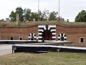
Main article: Concentration camp Theresienstadt
During WWII, the Gestapo used Terezín, better known by the German name Theresienstadt, as a ghetto, concentrating Jews from Czechoslovakia, as well as many from Germany, the Netherlands and Denmark. Though it was not an extermination camp, of the 144,000 Jews who arrived there, about 33,000 died in the ghetto itself, mostly because of the appalling conditions arising out of extreme population density. About 88,000 inhabitants were deported to Auschwitz and other extermination camps At the end of the war there were 17,247 survivors.
Part of the fortification (Small Fortress) served as the largest Gestapo prison in the Protectorate of Bohemia and Moravia, separated from the ghetto. Around 90,000 people went through it, and 2,600 of those died there.
It was liberated on May 9th, 1945 by the Soviet Army.

Terezín Terezín During World War II
After the German surrender the small fortress was used as an internment camp for ethnic Germans. The first prisoners arrived on the 10th of may 1945. On the 29th of February 1948 the last German prisoners were released and the camp was officially closed. Among the interened Germans were on one hand former Nazis like Heinrich Jöckel, the former commander of Terezín or other SS-members. On the other hand a great group of internees was arrested simply because of their German nationality, among them young boys of 12 years or elderly people.
In the first phase of the camp lasting until July 1945 mortality was high due to diseases, malnutrition and incidents of simple outright murder. Commander of the camp in that period was Stanislav Franc, who had been a prisoner of the camp under the Nazis since 1944. He was guided by a spirit of revenge and tolerated any mistreatment of the prisonsers by the guards.
In July 1945 the camp shifted under the control of the Czech ministry for domestic affairs. New commander became Otakar Kalal. From 1946 on the inmates were gradually transferred to Germany and Terezín more and more turned into a hub for the forced migration of Germans form the Czech lands to proper Germany itself.
A small exhibition nowadays reminds of the history of Terzín as internment camp for Germans.
Exhibition dedicated to the interment camp Terezín

Terezín Today

Monday, October 15, 2007


Dalhousie University
Coordinates: 44°38′13″N, 63°35′30″W Dalhousie University is a university located in Halifax, Nova Scotia, Canada.
As the largest post-secondary educational institution in the Maritime Provinces it offers a wide array of programmes, including a Medical Programme and the Dalhousie Law School. The chancellor is Dr. Richard Goldbloom; Dr. Tom Traves serves as president and vice-chancellor.

History
Dalhousie comprises eleven faculties:

Architecture and Planning
Arts and Social Sciences
Computer Science
Dentistry
Engineering
Graduate Studies
Health Professions
Law
Management
Medicine
Science Faculties
In 2005, 10,660 full-time undergraduate students and 2,640 full-time graduate students enrolled at Dalhousie. The final vote was No, with 57.3% of voters agreeing that the proposed improvements were unnecessary or should not be funded solely by student dollars. Had the referendum succeeded, the construction and renovations would have been funded through an increase in student fees of $10.00 per course, reaching a maximum of $100 per year, for several decades.

Current Issues

The current campus was designed by Andrew R. Cobb.
The school's Canadian Interuniversity Sport athletic teams are called the Dalhousie Tigers.
The first Friday in February of each year is Munro Day, a holiday celebrating financial contributions made to the school in its infancy by George Munro.
The newest building built on the Dalhousie Campus is the Kenneth C. Rowe Management Building.
Dalhousie's campus newspaper, the Dalhousie Gazette, was founded in 1868, making it the oldest student newspaper in Canada and one of the oldest continuously-running student newspapers in North America.
Dalhousie's colours of black and gold came from the jerseys worn by the Dalhousie University Rugby Football Club (who still wear those colours, as well as the school crest on their jerseys).
Among North American universities, only Harvard, Yale, Princeton, McGill and the University of Toronto boast more Rhodes Scholars than Dalhousie. Trivia
Further information: List of Dalhousie University people

Faculty members

Richard Bennett Hatfield, former Premier of New Brunswick
Scott Brison, Canadian Member of Parliament and past Candidate for leadership of the Liberal Party of Canada - Bachelor of Commerce
Barbara Fris, Canadian operatic soprano - Bachelor of Music (Performance) http://www.barbarafris.com
Alexander Keith, Founder of Alexander Keith's Breweries
Eric Demaine - MacArthur Fellowship recipient
Michael Leir, Canadian High Commissioner to Australia
Shaun Majumder, Actor/Comedian
Alexa McDonough, previous national leader of the NDP
Chris Murphy, Bassist and vocalist of rock group Sloan
Kathryn D. Sullivan, First American woman to walk in space
George Elliot Clarke, Author and recipient of the Governor General's Award
Charles Peter McColough, Xerox CEO "great American business leader"
Darrell Dexter, Leader of Nova Scotia's New Democratic Party
Kishore Mahbubani, former Ambassador of the Republic of Singapore to the United Nations, Dean of the Lee Kuan Yew School of Public Policy
See Dalhousie Law School for law school alumni.
Adel Iskandar, author. Alumni
The Dalhousie Tigers are the athletic teams that represent Dalhousie University.

Athletics
The Dalhousie University Rugby Football Club is the rugby union team which represents Dalhousie University. There are both men's and women's sides of the DURFC, with the men's side fielding both an A and a B team. The team colours are black and gold.

Rugby Team
Dalhousie University has been competing in the sport of rugby union in Nova Scotia since at least the 1880s.

Dalhousie University History
The DURFC women's side, since it is not an AUS sport, it is no longer eligible for the many awards they once were awards with. The women had had much success at wining the Academic All-Canadian awards year after year.

Notes

Dalhousie Law School
Dalhousie Tigers - varsity athletics teams
Fenwick Place
Fraternities and sororities at Dalhousie University
Rebecca Cohn Auditorium, a concert hall in the Dalhousie Arts Centre
University of King's College
Canadian Interuniversity Sport

Sunday, October 14, 2007


Sydney is a significant tourist destination, with 7.8 million domestic visitors and 2.5 million international visitors in 2004
Sydney Harbour

Main article: Sydney Opera House Sydney Opera House

Main article: Sydney Harbour Bridge Sydney Harbour Bridge
Since 1998, BridgeClimb has made it possible for tourists to climb the southern half of the bridge. Tours run throughout the day, from dawn to dusk and are only cancelled for electrical storms or high wind. Night climbs are also available. Groups of climbers are provided with protective clothing appropriate to the prevailing weather conditions and are given an orientation before climbing. During the climb, attendees are secured to the bridge by a wire lifeline. Each climb begins on the eastern side of the bridge and ascends to the top. At the summit, the group crosses to the western side of the arch for the descent. Each climb is a three-and-a-half-hour experience.

Bridge Climb

Main article: The Rocks, New South Wales The Rocks

Main article: Darling Harbour, New South WalesTourism in Sydney Darling Harbour

Main article: Kings Cross, New South Wales Kings Cross
Sydney Tower is Sydney's tallest free-standing structure, and the second tallest in Australia (with the Q1 building on the Gold Coast being the tallest). It is also the second tallest observation tower in the Southern Hemisphere (after Auckland, New Zealand's Sky Tower); though Sydney Tower's main observation deck is almost 50 metres higher than that of Auckland's Sky Tower. The Sydney Tower is a member of the World Federation of Great Towers.
Sydney Tower Skywalk, or just Skywalk, is an open-air, glass-floored platform circling Sydney Tower at a height of 260m above ground level. The moving viewing platform extends out over the edge of the main structure of Sydney Tower. This attraction is more than twice as high as the popular BridgeClimb walk to the top of Sydney Harbour Bridge. From the platform the seaward horizon is 58 kilometres away, although inland features such as the Blue Mountains can be seen at further distances. See Sydney Attractions Group.

Sydney Tower
Sydney is home to a number of established museums. The Australian Museum is the oldest museum in Australia, and is particularly renowned in the fields of natural history and anthropology. The Powerhouse Museum specialises in science and technology, and its exhibits include the oldest steam engine in the world with a rotating action that is still in operation. The Australian National Maritime Museum focuses on Australia's maritime history.
Art Gallery of New South Wales
Australian Museum
Museum of Sydney
Australian National Maritime Museum

Museums
Hyde Park contains well-kept gardens and approximately 580 trees; a mixture of Moreton Bay Figs, Palms and other varieties. It is famed for its magnificent fig tree lined avenues. At the park's southern end is the ANZAC War Memorial A monument consisting of a 104-millimetre gun from the German light cruiser SMS Emden. Any traveller who visits Sydney, should take some time out to go for a walk through Hyde Park. Centennial Park is located 4km south east of the Sydney central business district. It is suited for family picnics, horse riding, sightseeing, scenic walks and those who wish to keep fit. Those who wish to go horse riding may do so in Centennial Park, there is a place just across the road from the park, right next door to Fox Studios where one can hire a horse. It is also suited for those who wish to go bushwalking without straying to far from the city.
The Royal Botanic Gardens is the largest of three major botanical gardens open to the public in Sydney. One may enter the park free of charge and it is open to the public every day of the year.
Hyde Park, Sydney.
Royal Botanical Gardens, Sydney.
Centennial Park, Sydney
The Domain, Sydney

Parks and nature of Sydney
Sydney Wildlife World is a zoo in the city of Sydney. It officially opened in September 2006. It is located on the shores of Darling Harbour and is attached to Sydney Aquarium. The Sydney Wildlife World is unusual for a zoo in that it is entirely enclosed and air-conditioned. The indoor zoo features a one-kilometre walkway which snakes through 7000 square metres of enclosures. The enclosure features around 6000 native animals.
Taronga Zoo is the city zoo of Sydney, officially opened on October 7, 1916. It is located on the shores of Sydney Harbour in Mosman. Taronga is linked to Dubbo's Western Plains Zoo in terms of breeding programs. Taronga Zoo is home to over 2,600 animals on 28.7 hectares, making it one of the largest of its kind, and it divided into eight zoogeographic regions with numerous indoor pavilions and outdoor exhibits. Taronga Zoo has about 340 species and over 2600 individual animals. They are housed in a large variety of exhibits.

Wildlife
Sydney is renowned for its beaches and, with its warm climate, attracts people to the beaches almost all year round.

Beaches in Sydney
Large numbers of tourists visit Bondi Beach throughout the year with many Irish and British tourists spending Christmas Day there. Bondi Beach features many popular cafes, restaurants and hotels, with spectacular views of the beach. The beach itself is approximately one kilometre long.
Coogee Beach
Tamarama
Bronte The path in this image is part of the Bronte to Bondi walking track.
Palm Beach. Where Home and Away is filmed.

Bondi Beach
Manly Beach is a well known beach situated in Sydney's Northern Beaches. Manly Beach is highly popular with tourists and locals alike; a popularity rivalled only by the famous Bondi Beach south of the harbour. Travelling to Manly from Sydney's main ferry terminal, Circular Quay, takes 30 minutes by ferry or 15 minutes by the faster 'Jet Cat' catamaran.
Manly Beach's foot- and cycle path
Shelly Beach (Manly).
North Head. Scenes from M:I-2 Were shot here.
Manly Beach

Manly Beach

Main article: Fox Studios Australia Sydney Olympic Park

/ For more images of SydneyCLICK HERE